Background
Sarah Parcak (University of Birmingham, Alabama)
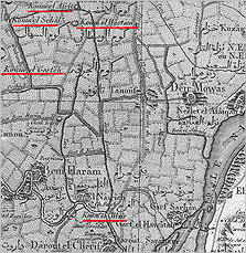
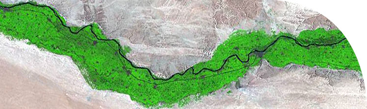
The Middle Egypt Survey Project is shedding light on settlement patterns along the Nile Valley through a study that combines satellite imagery analysis, ground-based survey and coring. It has as its focus a 15 x 20km area located in between Akhenaton's boundary stele on the west bank of the Nile across from Tell el-Amarna. This area has not been intensively surveyed since the Napoleonic survey almost 200 years ago. It is of great interest archaeologically because the relationship between Akhetaten and towns on the west bank during the Amarna period is not known. As well, the depositional history of the Nile is poorly understood in Middle Egypt.
Napoleon's team spent time surveying and mapping the region, and within the boundaries of Akhanaton's boundary stele identified 13 places of archaeological interest. Dieter Kessler's topographical study and visits in the region between Sammalut and Mallawi helps to shed light on potential ancient names for towns within the Middle Egypt survey as well as their function. Only by combining known sites from antiquity and modern names can an overall picture of remaining sites on the west bank become clear. Kemp has examined a variety of sources, and produced a map showing 27 potential sites within Akhenaton's boundary stele. In total, using primarily place names, around 30 sites appear in the survey area. R. Miller also cored at a number of sites on the west bank. Only Late Roman to Islamic period sherds could be identified from his surface collections and bore holes. In general this appears to be a flourishing period in the development of towns and cities in Egypt.
Given the large area of the survey, it would have been impossible to conduct a conventional foot-based ground survey. As well, this type of survey would be costly and time-consuming. Advanced approaches in ground survey using different types of satellite imagery would be necessary to locate potential new archaeological sites, which would be followed by a ground-based survey to verify the findings.
The project has identified 70 new archaeological sites.